

We left dad’s property mid-morning and headed towards Lamoille Canyon. The normal route would have taken us through the town of Elko, however there was construction on the highway that included some vicious bumps and perilously narrow lane closures. Instead of running the gauntlet, we opted to take the scenic route, a 25 mile long, purportedly well maintained dirt road that skirted the base of the Ruby Mountains. It turned out that the reports were mostly true, the road was relatively flat, with only minor washboards, and the views were spectacular….except, the gravel was very large and sharp. I wasn’t too worried because on our last trip we had three flats and replaced all four trailer tires. Well, I suppose I was wrong. At about the 15 mile mark Cate suggested we pull over and check on things in the camper since there were some washboards. As soon as I opened the door to get out of the truck I heard it. The hissing of air coming out of the Argosy’s tire. Hoping for an easily pluggable puncture (we keep a kit with us), I removed the tire only to find a large rock imbedded in the tread. We unhooked, locked the trailer hitch, left notes in the window and headed to town. Luckily a tire shop was able to get us fixed up,on the spot and at a fair price! After mailing mothers day cards we made our way back to the camper, and were soon back in action.


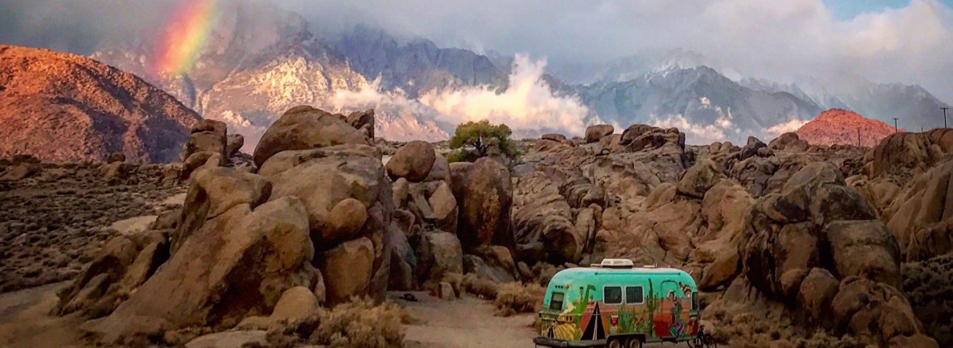
Less than 30 minutes later we were down in the canyon valley where a handful of dispersed sites were. We parked and scouted the dirt paths looking for the perfect spot. We settled on our spot and set up camp explored our little private beach area, and ate dinner as the sun slipped behind one canyon wall while the full moon rose above the other.

In the morning, Cate, as usual popped right up at dawn and shook me…. “hey, midge! Lets go!”… and off we went. Our first stop was a large craggy area near the entrance to the canyon, Franks bounded around the rocks with reckless abandon, while we nervously looked on reminding ourselves…”she’s a goat, she’s a goat, she’ll be fine!” At one point a marmot came out from under his rock to meet her.

When we finally convinced Frankie to come down from the rocks and get back in the car, we drove back up the canyon to a half mile trail called Valley View. It wound through the aspen trees that had 100 year old Basque graffiti carved into them and down along Lamoille creek and a series of giant abandoned beaver dams. It was amazing to see how large some of the logs were that the beavers had chewed down and used in the dams. Frankie even tried her best to emulate a beaver!


Afterwards we travelled a short distance back down the road to Thomas Creek campground and trailhead. It felt strange walking through the empty closed campground, kind of like we could be the only two people and goat left on earth. The campground was immaculate and the sites were laid out perfectly, most of them only steps from Lamoille Creek. We found the trail next to site 33 and started our climb into the Thomas Creek glacial valley. The trail ran beside the snowmelt-swollen creek the whole way. We passed waterfall after waterfall both beside the trail, and tumbling down the steep mountainsides in the distance. We hiked about 2 miles in before losing the trail and turning back.


Our hike had worked up an appetite and we had some errands to run so we went to Elko for a bit. Elko had a sizable basque population at the turn of the century which is still tightly ingrained in the fabric of the town. There are numerous murals on buildings with Basque themes, and we ate at a delicious Basque sandwich spot. The town was chock full of bars and casinos with terrific neon signs at every turn. There was even a tiny redlight district just off of downtown. One could surmise that if it wasnt for the pandemic, Elko would be El-KOOL and a hopping place to be in the warmer months!


 We finished our errands and eagerly headed back to camp, excited for our next hike, the Right Fork trail! This trail was at the back of a burned out Boy Scout camp within walking distance of the Argosy. The camp almost completely destroyed by a fast moving fire on my birthday in 2018. The fire ravaged the canyon in just 12 hours. Only the lodge foundation and fireplace, the bathrooms, and three of the A-frame cabins remain. We wandered through the camp and hooked up with the trail up into the side canyon along the Right Fork creek. We hike fore 3 miles through burnt forests, passing more beaverdams and passing many more waterfalls until we emerged on a large rocky area high over the valley. We rested a bit, and in consideration of the fading daylight, started our descent back down to camp.


The next morning Cate woke for sunrise and headed off to take pictures of the reflections at the beaver ponds and later we checked out a nearby waterfall and panned for gold (with no luck). Finally we had our traditional last night at camp “fancy” meal and talked about the next day’s journey to Utah’s Bonneveille Salt Flats. Which is exactly where we went the following day…


Oh I so love Lamoille canyon. We traveled through there and camped one year. It was gorgeous. Your photos as always are beautiful, Cate, and I so loved seeing Frankie in the rocks. Goat territory for sure. Love following along on your travels
Another great adventure, fantastic! OMG, I’m surprised to see that sharp rock went right into one of your new tires, jeez. Love following you guys, the pictures a wonderful as usual. Looking forward to your next journey. Be safe, be well ~
Gorgeous photos and grand prose.
I do love following your journeys.
Thanks for ‘ taking me along’.