
 After driving us out to pick up the newly repaired Yukon, we all gathered outside the Argosy and took a group photo. Afterwards, the spawns took their leave and pulled out of the Kingman KOA. I wondered if they were happy to be on their road back to normalcy or would rather have continued the adventure. Obviously it wasn’t a choice, everyone has obligations they must meet…. I also hoped their trip back across the country would be free of problems, and that they would thaw out on the way.
 We left Kingman and spent the night at a small BLM area outside of Ash Fork on Welsh Rd. The next day we made our way towards Flagstaff to gather some supplies and listen to the inauguration ceremony before heading South on state highway 89A towards Sedona. A giant snowstorm was about to descend on Flagstaff, of which we wanted no part of.

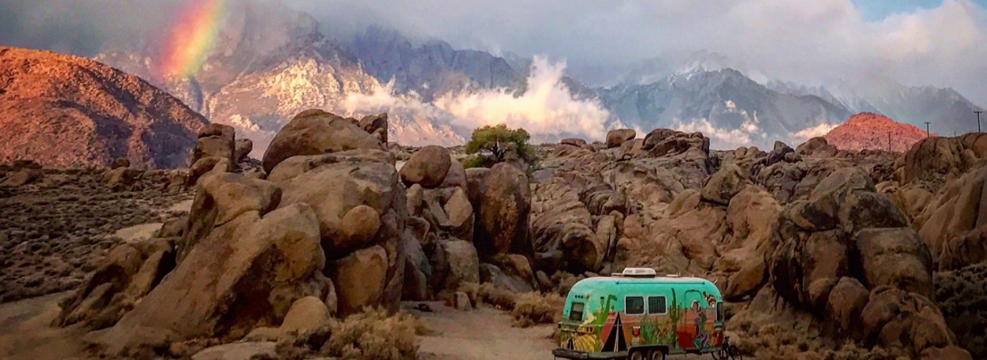
The last time we visited Sedona was four years ago, with Cate’s folks, and without the Argosy….where we were fortunate enough to stay in an actual hotel. This time we looked for a nice boondocking spot, perhaps with a view…. if we were lucky…and Cate identified an area that looked promising. A handful of miles Southwest of Sedona, on 89A, was a popular dispersed camping area on Forest Service land. We hung a right onto Forest Service Rd 525, and passed by a large parking area packed full of RVs, and continued down the rugged, but passable dirt road. We drove on, and on, and on. It seemed like every suitable pullout was taken, some campers even encroaching on others. As usual, whenever we start to lose hope in finding a spot, we push ourselves just a little bit further down the road, and around the next curve, hoping something will come to bear. Finally, after feeling that all the good spots had been taken, and the Argosy having been scrambled like an egg by the long rough road, we topped a rise, and a tiny overgrown side-road appeared to our right.
 We paused to scout the area on foot so as not to get ourselves in a situation where we would be unable to turn around. Having learned our lessons about other campsite-shoppers swooping into campsites while scouting, we strategically placed the Argosy across the access.*just-in-case*! Lo and behold, it was perfection! A nice loop around a lonely Juniper with sweeping views, and no one else around.
As usual we kept Frankie on the leash while Cate and I goat-proofed the campsite. Soon we were unhooked, the solar panel was deployed, and a huge sigh of relief came from both of us. It had been a trying few days, but now we had a great site and plenty of sights to see. We flew the drone around for a bit before making a fire and lighting up our faithful #Cobb Grill. It wasn’t long before the sun slid down, and the mesas lit up with a red fiery alpenglow. While retracing our route we found out that the place we stayed was called Mesa Tank.


The next day we woke up early. Our mission was to check out Prescott (pronounced “pres-cut”), and in particular Watson Lake. On the way to Prescott we dropped into Jerome. We had been there before, but it had been socked in with fog. This time however, we got the full mile-high view.
Watson Lake was incredible! Anyone that knows us knows that Alabama Hills is one of our favorite destinations/camping spots. Watson Lake is like a flooded version of the Alabama Hills. A 4.8 mile loop trail skirts the lake and offers great views of the surrounding terrain. Our hike was overshadowed by a significant chance of rain, but we sallied forth, much to Frankie’s chagrin. The rain held off and we made it back to the truck, but not before the Franks took a few breaks! LOL…


At the end of the day we stopped at Oak Creek to get dinner fixin’s before heading back to camp.The next morning we did our “cross check” and saddled up for the long drive South through Phoenix, making our way towards Tucson. Just before Marana we explored some camping options near Red Rock but found that all of the boondocking sites we had hoped for were rightfully taken by the snowbirds…I suppose the early (snow)birds deserve the terrain! We kept going to Marana and found a fantastic spot just off of Pipeline Rd. outside of Saguaro National Park in the Ironwood Wilderness. The area was perfect for our needs and we tucked up in between two ancient saguaro that our friend Annie later christened “Pancho” and “Lefty”.


As the sun set and the wind picked up, the needles on the Saguaro sang in the fading light. It was magical!
The next morning we set out to see Cocoraque Butte in the Ironwood Wilderness. The butte is a high spot of volcanic rock in the flat desert that has a trove of ancient petroglyphs on the rocks near the peak. The drive out to the butte was fun but arduous. Many sand traps and gates were traversed. We were happy that our new truck had the clearance and the wherewithal to deal with the conditions. Eventually the road ended at a fairly well developed parking area. There was no clear trail map so we relied on our spotty cell service to guide us. We walked the fence line on an extremely sandy trail keeping an eye on the Franks who seemed to be a magnet for the Jumping Cholla.


The desert up in the Ironwood wilderness, while beautiful, can look all the same from ground level. From the top of the butte we could see the the sun twinkling off of our distant truck windows, but as we descended to the desert floor to make the trip back to the Yukon, we lost our bearings. We decided to avoid the deep sand and jumping Cholla in favor of the harder packed cross-country route. We eventually had to send the drone up a couple of times to help find our way. We were successful and consequently robbed the buzzards of their next meal.
The next day we drove to Saguaro National Park West and walked the Desert Discovery Trail with Frankie, the only pet-friendly trail in the park. At only .5 miles, it didn’t take long so we chose to drive the scenic loop road (Golden Gate Rd & Hohokam Rd) with a stopoff at Sigal Hill to see more petroglyphs.

Soon enough we were back in the Argosy, packed and ready for our 3-hour drive to Organ Pipe National Monument which was 250 miles to our West. Organ Pipe had been on Cate’s itinerary for quite a while, and for the life of me, I couldn’t figure out why anyone would name a place in the desert “Oregon Pipe”. I was about to find out!
Next up, Organ Pipe National Monument and the Kofa Wildlife Refuge
Loved the travelouge and the beautiful pics and drone footage. How do you keep the camera still as you’re driving on those dirt roads? I live vicariously through your trips!! I biked up that road to Jerome, in my 20’s & chased a tarantula around with my camera, it was crossing the road.