

Leaving Leavenworth, we headed south on Highway 97 to Yakima before hanging a right towards Mt. Rainier. We were excited to revisit Rainier, which had been one of the least crowded parks we’ve come across, as well as one of the prettiest. On the way over White Pass we stopped at Clear Creek Falls Overlook near Dog Lake to admire a beautiful 228 foot waterfall that cascades into a sheer walled canyon, and I fired up the drone to fly out into the canyon and get some footage. Soon we were back on the road, and as we came around a bend, there was a pulloff that featured a massive panoramic view of Mt. Rainier. Unlike last time, the pulloff was full of people taking pictures of the mountain. As we pulled in with our distinctive painted Argosy, most of the people turned their cameras on us. This was our first indication that our visit to Rainier was not going to be as deserted as our last. It also made us a little more concerned about finding a dispersed site—we crossed our fingers, eyes, and hooves and set out to find our camping spot.
At the bottom of the grade we hung a right on US123 towards the park. At the third pulloff, we unhooked the camper, locked it and chocked it, and left a note with the date, time, and phone number. It’s much easier to scout for dispersed campsites without towing, just in case you get in a tight spot and can’t turn around! Our hunch about the sites being full was correct.

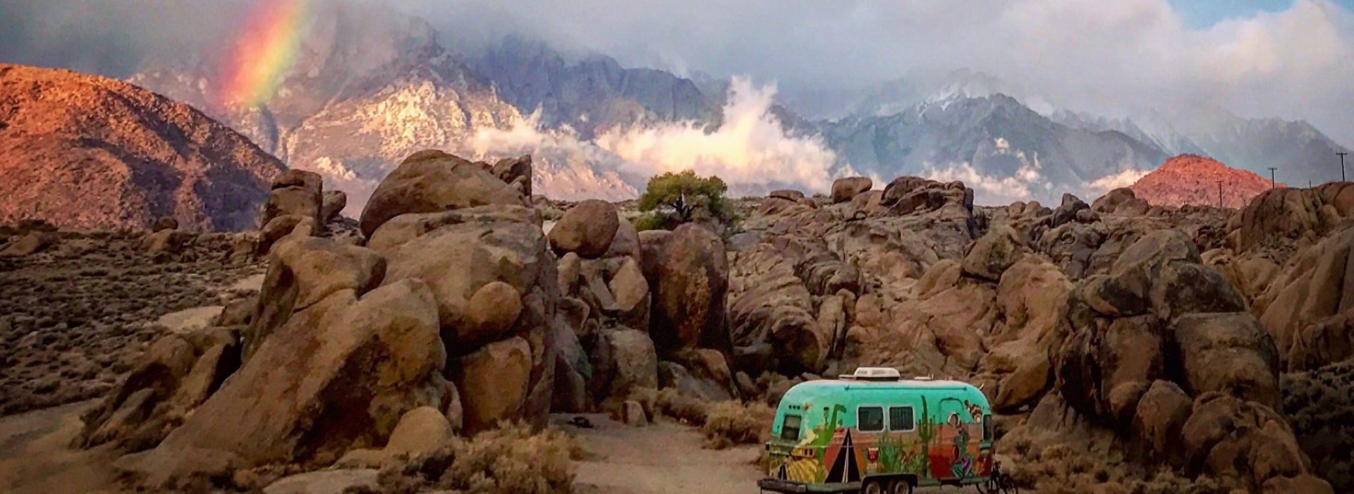
Luckily for us, and somewhat ironically, we found the last open spot- a wonderful shaded dispersed campsite a little further up Forest Service Rd 44 from a site we had camped at 4 years ago! We threw down our camp chairs and table to show the site was ”taken” and within 20 minutes, we were backing the Argosy carefully back into the trees! The site was clean, quiet and couldn’t be seen from the road. The gurgle of a small creek somewhere off in the distance added to the ambiance.


With camp set up, we made a quick trip to the nearby town of Packwood for supplies. The town had changed quite a bit since the last time we were there. There were new restaurants and even a brewery with a huge lawn! You wouldn’t have guessed there was a Pandemic in Packwood, like Leavenworth, the streets were buzzing, restaurants busy, motorcycles cruised the drag. It was like a snapshot to a simpler time, still we kept our distance. Supplies procured, we set off for the mountain, flashing our park pass we cruised through the entrance and headed for Paradise. We drove up the steep winding road behind long lines of cars, every overlook was packed.

Finally we turned into the Paradise parking lot and were again amazed at the sheer volume of people. In case you haven’t noticed by now, that is going to be the secondary theme of this blog entry. The plan was for me and Frankie to hang around the parking lot, surf the web, etc. while Cate went to take pictures of the incredible wildflowers at Paradise Meadows between the tree-line and the glaciers. Remember, no pets are allowed outside of parking lots in most National Parks. Instead we hopped out and took a few pictures of a nice slot canyon-y waterfall and decided to come back first thing in the morning when the crowds would be non-existant. We continued on, explored the park a little more and then retired for the evening.


To beat the crowds, Cate drove up to Reflection Lake and Paradise at sunrise to hike the Skyline Trail and explore Myrtle Falls while Frankie and I stayed behind and slept in 😜. Later in the morning she came to retrieve us and I was able to do a fantastic hike to Pinnacle Peak. This trail gains 1,050 feet in 1.25 miles, its quite a climb but only 2.5 miles round trip. I had to do this hike alone…Did I mention no non-native goats on trails? Luckily I saw very few people on that hike!


Later on in the evening we returned to Packwood and sat far out on the Lawn of Packwood Brewing, where we enjoyed some of their delicious chips & queso and chatted with a very nice couple from Portland.

Our last full day at Rainier, we woke up before sunrise and headed to the edge of the park, near Tipsoo lake and the Chinook Pass. We arrived just as the sun was rising over the valley below. I flew the drone, but the morning light was a little too much for it.
 Cate took some nice pics, and in order to beat the crowds we started our hike to Sourdough Gap! This hike is 7 miles (out and back) along the Pacific Crest Trail, and is just outside the park meaning that The Franks was welcome! It passes Sheep Lake, a popular camping spot for through hikers, and though trail traffic was light, when we arrived at the lake there were a few camps set up near the lake. The wildflowers were amazing…Indian Paintbrush, Lupine, Shooting Stars, all in bloom. The lake was still in the early morning, and aside from the wind it was quiet. Careful to avoid disturbing the slumbering PCT hikers we took a few photos and headed towards Sourdough Gap. As we neared the gap we paused for a bit and again broke out the drone in an attempt to catch the stunning scenery from a unique viewpoint. Shortly thereafter we found ourselves at the gap looking over into another valley with scattered patches of snow, scree, and abundant wildflowers.
  The decision was made to hike onwards about another half mile to the Crystal lake viewpoint where we hoped to take in more sweeping views of Rainier, but the morning fog obscured our view. We eventually backtracked to Sourdough Gap and drank our “summit ciders” while Frankie scratched out a place to lie down and we reveled in the view.


Too soon it was time to head down, the morning fog was lifting and the sun was starting to heat things up. On the way back, we passed many people that were just starting out their day. It was a narrow trail and we were impressed by the amount of hikers that not only brought their masks, but would put them on while we passed. After returning to the truck, legs thoroughly worn out, we made the drive up to Sunrise visitor center. This is the location where we simultaneously saw the full moon set and the sun rise just a few short years ago. The parking lot was crowded, and we were spent from our early morning hike, so we opted to grab a sandwich and head back to camp.
Our time at Mt. Rainier was almost up, we made dinner, relaxed a bit at camp and headed out early the next morning for a quick drive-by of Mt. St. Helens. We had been fortunate enough to have visited Spirit Lake, Lava Canyon, etc. on the East and South sides of the mountain a few years ago. This was our first visit to the North side of the mountain, where the crater and the eruption’s most obvious effects are visible. Exiting I-5 at Castle Rock, we continued on 30 miles towards the Johnston Ridge Observatory, briefly stopping at the buried A-frame and bigfoot statue in Kid Valley. We ran into the owner and had a very entertaining conversation about hunting sasquatch and she proudly showed us her Bigfoot intercept vehicle (a fully decked out humvee that looked like it had all the original military electronics still in tact)! We eventually made it to the Loowit Viewpoint and snapped a few pics before retracing our route to I-5.


We pointed truck and trailer South and made haste, hoping to be home by dark.
Cate’s birthday trip, like most trips had it’s share of challenges, and that my friends is half of the fun. We were very lucky to have visited every point on our agenda, were blessed with some great campsites, epic views, good weather, and exhilarating hikes. Thanks for following along with us, we will be heading out again in January…. hopefully with the spawns again, until then we will be doing a plethora of tent camping and posting them on our new day-trips and overnighters page! Stay safe friends! Be kind to one another!
What date were you there? I know this was posted in September, but the wildflowers weren’t in bloom then, even at high elevation, I assume. Great post.
Hi Dan! We were there in August. Depending on where we went, the flowers were peaking in most places except at Paradise.
Lovely photos! And a nice post. I felt I were hiking along with you. And, man, do I need to take a trip!
How do you find the places to hike when you’re not staying in a National Park? Have you just gotten really familiar with them over the years, read lots of books, or what? And do you use topo maps for some of the longer hikes?
We’re heading up there in the Oct/Nov timeframe. We’re hoping crowds will be smaller with schools being in session. Think they’ll thin out by that time?
Allison
Hi Allison! I’d check out our recent blog post about boondocking that goes into how we find places. We boondock on NF and BLM land, and unless you see a “day-use only sign” or “no camping” sign, it’s pretty much fair game. Beaides the Dyrt app, freecampsites.net, FreeRoam, Allstays, Campendium are helpful along with asking the local ranger station. Or unhook the trailer and explore potentional forest service roads. it’s an adventure!
Hi Allison! I’d check out our recent blog post about boondocking that goes into how we find places. We boondock on NF and BLM land, and unless you see a “day-use only sign” or “no camping” sign, it’s pretty much fair game. Besides the Dyrt app, freecampsites.net, FreeRoam, Allstays, Campendium are helpful along with asking the local ranger station. Or unhook the trailer and explore potentional forest service roads. it’s an adventure!
Loved this!! Thanks for sharing!
thanks lady!!!! ❤️